Click Image For The Sailboat Company's Home Page
Fall Cruise 2018
Everyone has his or her boat ready because good weather is just around the corner? I’m writing this in August and it’s a good time to think about fall and to do some planning. Some of us are going on a fall cruse this year. One that we should have done several years ago but we were too busy to get out and get it done. Where I live, a great fall cruise is from Jacksonville, NC up and around the coast of North Carolina to Beaufort, NC and then up the Newport River and Adams Creek to the Neuse River and Oriental, NC. After spending a few days in Oriental, the journey will continue up the Neuse to New Bern, North Carolina. I made this trip many times many years ago and I’m anxious to see what has changed. If the weather is good, we may take a run out to Cape Lookout when we pass through Beaufort. Cape Lookout is always a "spend the night" adventure if you are doing the Cape in a sailboat. Going out one day and coming back the next day is routine.
I remember from childhood, thinking about something is almost as good as doing it for real. The crew and the captain are going to need a week of time off from their jobs. That will take some planning or maybe a little magic in some cases. The boat will need anchors and rode and fuel and water and all the stuff we might need on a trip. We normally take too much and always have at least one item that we forget to take. We will have a Porte Potty and all the other Coast Guard requirements and not have to worry about those coastal inspections. Since we have a whole week to make the trip, we will plan to sample some of the best seafood restaurants on our North Carolina coast. I just remembered the anchor light. I have to get one for sure.
What we noticed in the past is sailboats stay clean on cruises. When a boat is in a slip, people keep tracking dirt on the boat with their shoes. Captain and crew walk on docks and other clean surfaces while cruising. A clean boat is a happy boat and everyone feels better. Our boat is going to get broken in again. Everything will be working smoothly by time we get back. All those rough spots we see when we day sail will be gone. The boat and the crew needs time together to smooth out the rough spots. Some of the nicest people you will ever want to meet are on the waterway. After a week on the water, everyone’s attitude about life and living will improve for the better. Who knows; slow cruising might make people livelonger?
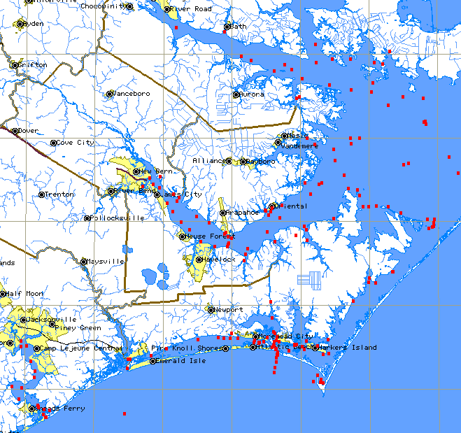
Departure will be in mid October. North Carolina weather is perfect in October and November for comfortable sailing. 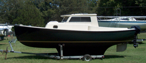 We will proceed down the New River and go under the Highway 24 Bridge. Our boat will be a Com-Pac 23 Pilothouse with an outboard motor for power. The Bridge has a 45-foot clearance and the Com-Pac will have no problems with that height. The next major body of water is Morgan Bay and that has Marine Corps installations on both sides. The Marine Corps frowns on unauthorized landings on their property. Morgan Bay is a beautiful body of water and an excellent place to sail. The State owns the water in North Carolina and everyone is welcome to sail on the New River. Civilians can launch at either end of the New River and sail anywhere on the river.
  The New River is divided into many smaller bays after Morgan Bay. We will follow the bays and the day marks until we reach the Snead’s Ferry Bridge. It’s another 45-foot Bridge and no problem for the Com-Pac.
The town of Snead’s Ferry lay to starboard after the bridge. The town has a great restaurant called the River View about a mile down river from the bridge. A closed commercial fishing company is next door to the restaurant. Eating at the restaurant and then spending the night at anchor next to the fishing company sounds like a plan. Days are getting a little short in October. If we leave Jacksonville by 8:00 AM, we should reach the restaurant by 4:00 PM for dinner and have some extra time to anchor. We will need to leave Snead’s Ferry at first light. Snead’s Ferry to Beaufort is a long stretch with a number of obstructions that may take extra time. A fall back plan will be to stop at Moorhead City instead of Beaufort. That’s an hour’s difference in our ETA. A second fallback plan is Swansboro, North Carolina. That’s only 10 miles from Snead’s Ferry and too close to be practical. Swansboro to Moorhead is another 12 miles with no stopping in between. You can’t anchor on the Inter-Coastal Waterway. You need to anchor off the waterway for safety purposes. Tugs and barges move up and down the ICW at night and anchoring on the waterway would be dangerous. The ICW between Snead’s Ferry and Swansboro has one swing bridge with no vertical clearance. It opens on the hour and the Marine Corps stops waterway traffic during the week about a half-mile from the bridge. They practice live firing with artillery. They have an impact area between the mainland and the ocean. If you hit those obstructions in a timely fashion, getting to Beaufort is no problem. This is assuming that everything is the same as it was 20 years ago. Snead’s Ferry to Beaufort is 30 miles or 6 hours if you can average 5 miles per hour. Mile markers on the ICW are 10 miles apart. If you boat can do 6 knots, good food, a comfortable dock and clean restrooms are available at the City Docks in Beaufort. I kind of like the Fudge Factory if it’s still operating. Beaufort also has several restaurants that serve breakfast, my favorite meal of the day. There are several good reasons to make miles on the ICW to Beaufort.
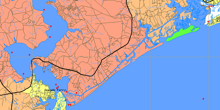
As we leave Snead’s Ferry, we head for mid channel making sure we know the tide tables for that day. Snead’s Ferry is located on a river that exits the mainland at a coastal inlet and also crosses the ICW in the same area. Tidal currents can get complicated. We will head for that junction and make a hard turn to port. If we continued straight, we would be going out a closed inlet. The Coast Guard will close an inlet when it isn’t being maintained. They pick up their channel marks and publish in Notice To Mariners that the inlet is closed. Closing the New River Inlet shut down most of fishing businesses in Snead’s Ferry. That’s why we can spend the night at their facilities. Sailing in the ocean between Beaufort and the New River Inlet is the quick route. If the weather is good and the wind is right, it can be hours faster. In the old days, we would count the water towers on land to keep track of our progress. This time we are going to take the slow scenic inside route to Beaufort. As we continue up the ICW, we are going to pass Hammocks Bay to port. The land around the bay belongs to the Marine Corps, however the bay itself has been a safe harbor for snowbirds that move their boats north and south. They have seasons in the spring and fall. We might see a few in October. It’s a middle spot to spend the night between Beaufort and Wilmington. It’s only a short distance to the Onslow Beach Bridge and timing is really important. No one wants to spend an hour waiting for a bridge to open. After the bridge, it’s only a short distance to the Marine Corps firing range. The Marine will be in a small boat stopping traffic coming from both directions. Looking to starboard, you can see the targets on the Marines live fire range. Mostly jeeps and trucks are the targets. I remember firing on them from helicopters many years ago. Keeping your footing in a helicopter when it’s diving on a target is interesting. The next major landmark is the Red Barn. It’s a grocery store that been there for a long time. The people at the store tell a story about an Englishman that lost his boat off the coast, swam ashore and walked through the coastal islands and swam across the ICW to ask for help. It all happened at night during a hurricane. He was a strong swimmer. The small village of Swansboro and the White Oak River is our next attraction on our cruise. When you get to a congested area, traffic can be a problem and this is compounded by another river and inlet. I have had some exciting moments in Swansboro in the past. I don’t like to talk about it, but I have gone aground twice at the same spot.
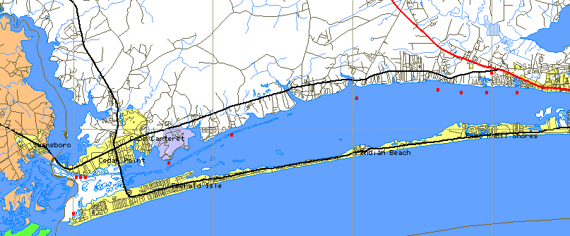
The White Oak River enters the ICW at Swansboro and travels down the ICW about a mile before it turns to starboard to exit out Bouge Inlet. If the current is running strong and you are not on the ball, you can go aground. I know of what I speck. The next bridge is a 65-footer at the north end of Swansboro. The ICW is basically an almost straight line until you get to Moorhead City. The best way to get to Beaufort is to almost go out Beaufort Inlet and turn to port into a channel leading into Taylor Creek and Beaufort. The City Docks in Beaufort are on Taylor Creek. They are in a central location and most attractions are within walking distance. I really like to watch the boats come and go and watch the people watching boats come and go. The town has good food and it’s good place to rest and stretch your legs. It’s also a good jumping off place if you plan seeing Cape Lookout. The current runs strong in Taylor Creek and boats in transit slips away from shore have the most difficulty docking and undocking.
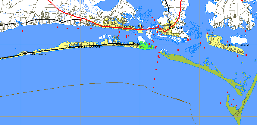
You can see the lights of Beaufort from Cape Lookout at night. It’s only about 5 or 8 miles to the Cape. The distance depends on the way you get there. Going out the inlet and hooking a left at one the channel markers is the fast way. When you get to a channel marker where you can see the Cape Lookout Light, that’s the place to make your turn for the Cape. You don’t have to go all the way to the sea buoy. You need to stay off the beach some distance while going between the two. Blackbeard’s ship, the Queen Anne’s Revenge is located on the bottom close to Beaufort Inlet. The Cape Lookout inlet is at the southern end of the Cape and well marked. I like to anchor over by the old Coast Guard Station where the water is 9 feet deep. The Bite has water that’s 26 feet deep with a very hard bottom that makes anchoring difficult. Most people walk the beach on the ocean side and the Cape side while they are there. There used to be lots of clams under the Coast Guard dock several years ago. Dipping clams in butter with a cold beer is pretty good. The water is so clear you can see your anchor in 9 feet of water. It might be a good time to clean your boat’s bottom. Keep in mind that I keep catching 10-pound sharks on my McDonald’s paper straw. I think they like the color.
If the wind is blowing stink out of the south the next morning, it time to go home via the back door. The back door is protected from south a wind, but not from north winds. The front door is protected from north winds, but not south winds. Works pretty well. To use the back door we head for inlet next to the light. The one the ferry uses to take visitors to see the Cape from Harker’s Island. It goes through a winding channel to Back Bay that runs along the east side of Harker’s Island. 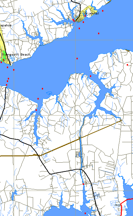 At the south end of the bay, a channel crosses over to the South River. Continue down the South River a short distance and another channel connects to Taylor Creek with Beaufort at the other end. I have made that journey in a 4-foot draft sailboat before. You can sail if you go the front door, but the backdoor is a motorboat trip. Both ways are beautiful and can be exciting. Large ship waiting to be loaded or unloaded anchor outside the sea buoy at Moorhead. Sailing around those big ships that come from all over the world is pretty cool.
After staying a few days in Beaufort, maybe one in a Motel, it will be time to start the next part of our cruise. I normally leave Beaufort going north via the Gallant Channel. It bypasses the Turning Basin and the dock areas of Moorhead City. It’s kind of a short cut if you are going north up the New Port River. The big problem with the Gallant Channel is the Channel is perpendicular to the current that’s flowing down the New Port River and out the Beaufort Inlet. Sailboats have keels and when the water is moving sideways, so is your boat. After a starboard turn, the Gallant joins the New Port River. This area of the New Port is like being in the water in the middle of a field. The surrounding terrain is very low and has many creeks and streams. Some sailboats have encountered 65 knots wind in this area and they ended up aground in the marshes. This is not a good place to be during an afternoon squall. After the marshes, the river continues through forested areas with homes and commercial boat businesses on both sides. There is 65-foot bridge to go under before ICW runs into the junction with Adams Creek. I always feel like I’m motoring uphill in this area. I’m sure it’s only smoke and mirrors. We continue down Adams Creek until we exit the creek at the Neuse River. Looking across the River, you can Oriental, North Carolina in the distance. The sail or motor from Beaufort to Oriental is a short trip. We could turn to port and be in New Bern in 3 hours or continue on to Oriental for another good meal and one more nigh on the boat. We normally stay at Whittaker Creek Marina if they have room for a transit. There are 23 Marina in Oriental. If Whittaker doesn’t have one, we will find a slip somewhere. The M&M has the best food and we like the M&M. Many years ago, the best was the Trawl Door. We really miss that restaurant. I have lots of found memories from the Trawl Door. Keeping a boat in New Bern and sailing to Oriental on the weekends may be the best sailing on Earth. Good food, great people and wonderful place to sail. Can’t get any better except maybe for a Fall Cruise now and then. Did I tell you that Oriental is the jumping off point for Silver Lake and Oracoke Island.
The next day we will be looking for 10 to 15 knots of wind out of Northeast for our last day on the water. We will beam reach from Oriental to Marker #8 at Minnesott Beach. Then we will pickup speed and fly all the way to Duck Creek on a close reach. We will pinch and then fall off as the wind comes off the terrain on the high side of the river. We will be doing 6 knots and heeled over about 20 degrees most of the way home. Everyone is going to have a big smile on their face.