 Click Image For The Sailboat Company's Home Page
UpWind Sailing Manual Part 1
This manual uses an Android Tablet and Software to measure and record your sailing performance upwind. Sailing well upwind and sailing fast are two of the most important capabilities that any sailor can have. This Manual will show you step by step how to use the Tablet and the UpWind Software. The idea is to store the details of your upwind sailing performance in a database for comparison purposes. Keeping track of sail shape, rig adjustments, wind speed variations and the current requires lots of memory work or lots of experience. A database that shows what works and what doesn't work and why will make new sailors good sailors and old sailors even better sailors. The programs were written on a phone and pictures show phone images.
Don't worry about using the little 10-inch tablet. It’s not going to bite. Turn it on and hit the software button and that's it. You will have to keep it charged. Battery life varies with the brand of tablet. It has a built-in GPS and that's what makes all of our measurements possible. You can't screw it up and it didn't cost that much in the first place if you drop it overboard. I install the software at The Sailboat Company and I sell the Tablet. Check with me by email on when it will be available.
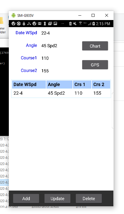
Click on the UpWind Icon and the program starts. The first screen is the database. It will come with one published entry. That entry shows a real good sailor that sailed upwind at 45 degrees. It gives you a date, a wind speed calculated from the appearance of the water's surface, your pointing angle and course 1 and course 2. There are three database buttons at the bottom of the screen. One is Add, the second is Update and third is Delete. I will explain how these buttons are used when we save an entry. The two buttons on the right top of screen are navigation buttons. The top button is the Chart button and the bottom one is the GPS button. The Chart button takes you to a Chart displaying the top entry in the database. I will explain the Chart when we get to Charts. The GPS button brings up our next screen.
The GPS screen is the heart of the program. It does most of the work and all of the calculations. When the Satellites on the left side of the screen report true, the software is ready to work. Push the Control button once when you are ready to start your first leg. You are going to sail upwind on one leg and tack and then sail up wind on a second leg. A label will say Start before you Start and then Starting Leg 1 after you push the button once. The software will be recording your first course during this period time. You can sail this leg for as long as you like. Sail as close to the wind as possible using sail shape, heel angle and any other tricks you may have. It goes without saying that you should point up in guests. Push the Control button again just before you tack. The label will say tack and then say Starting Leg 2. Sail Leg 2 like you sailed Leg 1 and when it's time to stop, Push the Control button a third time and the label will say Finish. The results of your sail will be displayed on the face of this screen. They include the date. The wind speed that you pre-calculated by looking at the surface of the water. That calculation is: 0 to 3 = Slick water, 3 to 8 = dark patches on the water, 8 to 12 = dark patches everywhere, 12+ = white caps, 18+ = white caps with the tops blown off. How close you came to the wind or your pointing Angle, the course for leg 1 and leg 2. The most important figure here is the Angle. Most sailboats sailed well should be around 90. That's 45 degrees to the wind. The wind direction is in the middle of the 90 degree angle or whatever angle you might have. On the coast, current is a consideration and looking at a stationary object to identify current is important. If you have current; one leg is going to be real good and the other real bad.

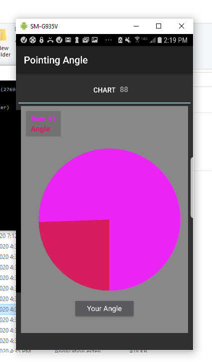
The buttons at bottom of the GPS screen do lots of work. The Control button we have talked about above. The other two buttons are navigation buttons. The Back button take you back to the database screen and copies the GPS data into the top portion of the database screen. This data can be deleted, shown in chart form or copied to the database. The software will not allow duplicate entries in the database. It will prevent it from happening with a message. If you look at the first database entry, you will see what a 90-degree angle looks like. That angle or better is what we want to achieve in different wind conditions. The other button is the Chart button and it does the same thing as the database chart button, but for the current GPS screen data. The image below is the 45 degrees to the wind chart. Can you do it?
OK, How is this program going to make me a better sailor? Currently, some of your tacks are good and some of them are bad. You will never do 45 degrees to the wind with a bad tack. You rig is just right sometimes and not so good other times. When you keep track of good and bad, the good will get better with a little time and effort. A Com-Pac 23 will go 1/2 knot faster with a little luff at the top of the main. Can my sails be tensioned to get 50% camber in the main and 33% in jib and at what wind speed??? Does my boat point better with a 3-degree slot or does it point better with more and at what wind speed??? Knowledge is power and that's a fact.
Years ago sailors got their experience sailing in groups or racing sailboats. That doesn't happen anymore, but we still need some way to compare our boat's performance with other boats. That's how we learn and that's how we get our experience. Years ago, some inexperience sailors said the Com-Pac 16 couldn't point because of its shoal keel. I think they were overpowering the keel and couldn’t point their boat from inexperience. This new equipment should help us become excellent sailors quickly and with your help, we can publish the true facts about boat performance.
A sister program that comes with the Tablet is Speed and Direction. We will use a separate Manual to explain its operation.